Skip to content

NCCA/ImageHeightMap

Folders and files

NameName
Last commit message
Last commit date

Latest commit


History

26 Commits


Repository files navigation

ImageHeightMap

alt tag

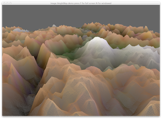
This demo shows how to read in an image and create terrain from it by using one of the channels as the height of the vertex in the y.

The program requires the image name to be passed on the command line (or within Qt Creator) The following images are in the textures directory.

alt tag

alt tag

About

Using images to create terrain

Resources

Stars

Watchers

Forks

Releases

No releases published

Packages

No packages published